


GPS — a global positioning system designed for determining location and navigation.
It has become a part of everyday life, helping us find our way, track vehicles, and coordinate actions in challenging conditions. However, despite the technology's ubiquity, how it works remains a mystery to many. Let's explore how GPS determines coordinates and how accurate this data is.
In simple words
GPS (Global Positioning System) operates using a network of satellites that continuously transmit signals indicating their location and precise time. On the ground, a GPS receiver (such as in a smartphone) detects these signals and measures the difference in their arrival times. By comparing data from at least four satellites, the receiver can calculate its precise location using triangulation. Knowing the signal's propagation speed and the time it takes to travel across the satellite, the system calculates the distance to each satellite, allowing for highly accurate coordinates.
The basis of GPS is the precise time recorded by the atomic clocks of each satellite. The system accounts for even the slightest errors to ensure high accuracy—down to several meters.
Basic principles of GPS operation

The GPS (Global Positioning System) was developed for military purposes in the US in the late 20th century, but today it is used in most mobile devices. It operates on the principle of satellite navigation: to determine a location, a GPS device communicates with several satellites and calculates the distance to each one. This is done using triangulation, a method based on precise time measurements.
Each satellite transmits a signal containing the current time and its location at the time of transmission. A GPS receiver on Earth records the time the signal was received and, using the speed of radio waves, calculates the distance to the satellite. To accurately determine a device's coordinates, signals from at least four satellites are required. This is necessary to eliminate measurement errors caused by varying atmospheric conditions and signal delays.
GPS components and their functions
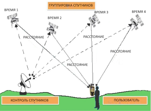
GPS consists of three main components: the space segment, the ground segment, and user receivers.
- Space segment The system includes satellites that orbit the Earth and provide complete planetary coverage. There are approximately 31 satellites in orbit, each orbiting the Earth twice daily. The satellite distribution ensures that signals from at least four of them are available at any point on Earth.
- Ground segment It is a network of stations that track satellite orbits and correct their positions. This ensures synchronization and the accuracy of transmitted data.
- Custom receivers These are the devices we use: navigators, smartphones, and car systems. They receive and process signals to determine their location.
Each component performs its own function in the system, and only their coordinated interaction allows for high accuracy and stability of GPS operation.
The Role of Accurate Time in GPS Operation
Accurate time is one of the key factors that ensures the operation of the global positioning system. GPS satellites constantly transmit signals containing the current time and their coordinates. A GPS receiver on the ground receives these signals and, by measuring the difference in the time of their reception, determines its distance to each satellite. These measurements are based on the speed of light: the time difference indicates the distance the signal has traveled while traveling at a constant speed. To achieve this, the process must account for the slightest errors, as even billionths of a second can result in deviations of hundreds of meters.
The satellites are equipped with atomic clocks that ensure maximum accuracy, which is critical for GPS. Even minor errors in timekeeping lead to significant distortions in coordinate determination. For example, if the clock on one satellite is off by even one millionth of a second, it can cause a position error of up to 300 meters. Therefore, the satellites' atomic clocks are periodically synchronized with ground stations to maintain accuracy within a few nanoseconds.
Furthermore, accurate time helps correct for signal delays caused by passage through atmospheric layers—the ionosphere and troposphere. These layers slow the signal, and to accurately determine the distance to satellites, the distorted transit time must be taken into account. Without accurate time, it would be impossible to account for and correct for such delays, which would impact positioning accuracy.
That is, precise time is the basis for GPS operation: it allows for the synchronization of signals from satellites, ensuring the most accurate determination of coordinates on earth.
Accuracy and factors affecting GPS performance
GPS is highly accurate: most modern receivers can determine coordinates with an accuracy of up to 5-10 meters. However, several factors can affect accuracy:
- Ionosphere and troposphere. When a signal passes through atmospheric layers, it slows down, which can cause deviations in calculations.
- Signal reflection. In urban environments, signals can be reflected from buildings and other large objects, creating multipath distortion.
- Receiver quality. More expensive and powerful devices are equipped with advanced filtering and correction algorithms, making them more accurate.
To solve these problems, differential GPS (DGPS) technology is used. It incorporates ground stations to correct signals, increasing accuracy to within a few centimeters. DGPS is used in surveying and other areas where precise positioning is essential.
Using GPS in Everyday Life
GPS has found applications in a wide range of fields, from simple navigation to scientific research. Among the most common applications are:
- Car navigation. GPS helps drivers plan optimal routes and avoid traffic jams.
- Sports equipment. Fitness trackers and GPS watches help track distance, speed, and route.
- Mobile applications and maps. GPS has become a standard feature in most smartphones, allowing for the use of location-based apps.
- Agriculture. The use of GPS in agricultural machinery allows for precise planning of crops and harvesting.
- Avionics and maritime navigation. GPS systems are used to plot routes for aircraft and ships, making travel safer.
GPS and Security: Impact on Privacy
The use of GPS technology is not limited to obtaining geolocation data. Its widespread use also raises privacy concerns, as apps and devices can track a user's movements. Many companies collect this data, which can pose a privacy risk. There are several precautions you can take to protect your data, including limiting app permissions and using a VPN.
Conclusion
GPS has become an essential part of our lives, providing access to geolocation and navigation in real time. Although the technology was originally developed for the military, it has now expanded to encompass virtually every aspect of life, from logistics to personal use. GPS accuracy and capabilities continue to improve, opening up new opportunities in scientific research and industry.